
Travel
Largest Islands in the World
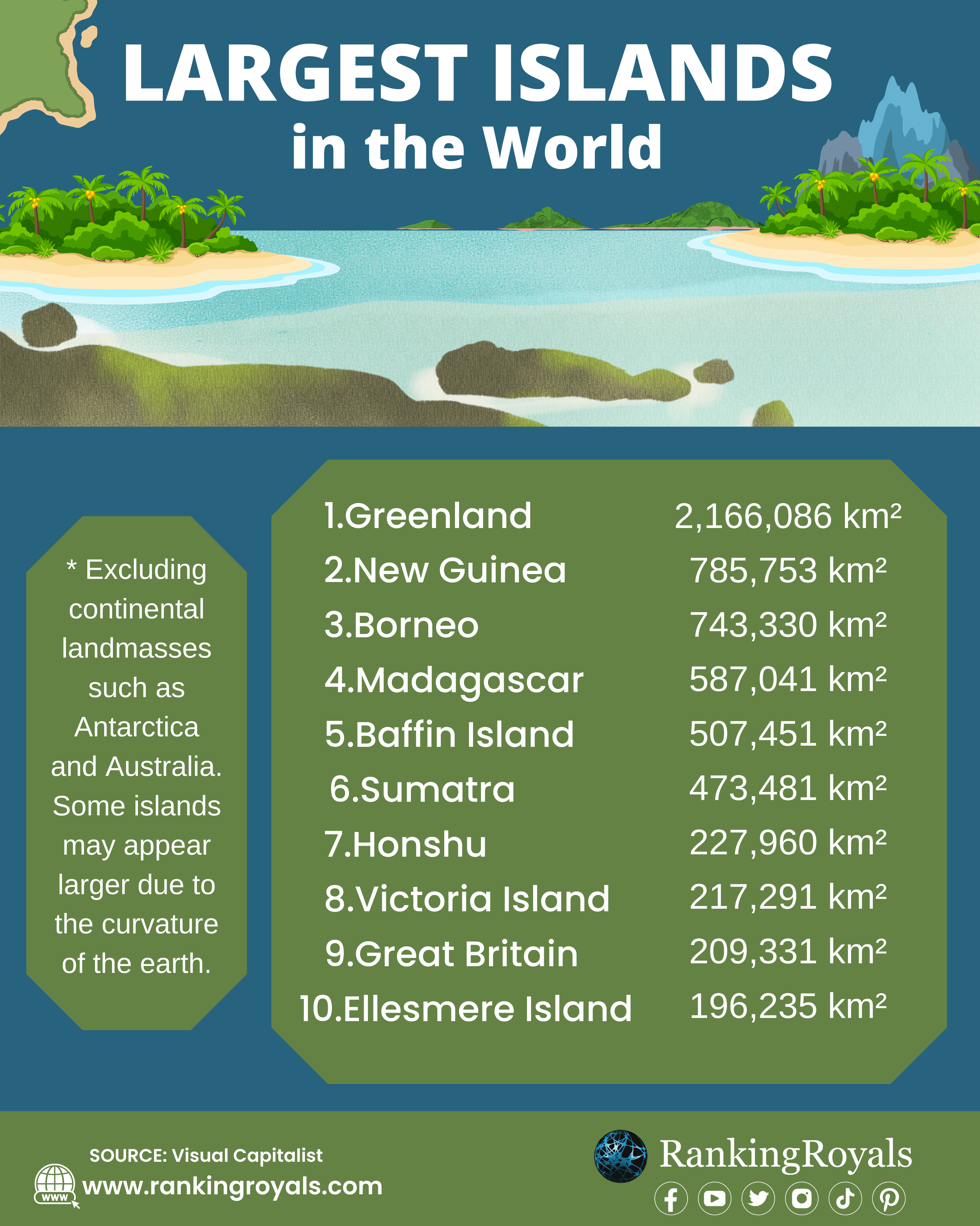
The islands are always fascinating to people for their own geographical characteristics, historical background, and diversity of culture. There are some islands that are small and uninhabited, while others are large and densely populated. We’ll take a look at the largest islands in the world, ranging from Greenland’s frozen wilderness to Madagascar’s tropical paradise. These islands are a splendid example of our planet’s natural wonders and cultural heritage, and their massive size and scope will undoubtedly take you by surprise. So let’s start a journey to discover the largest islands in the world.
What are the world’s 10 largest islands?
1. Greenland
Greenland is the world’s largest island, with an area of 2,166,086 km². It is situated east of the Canadian Arctic Archipelago between the Arctic and the Atlantic Oceans. It belongs to the Kingdom of Denmark as an autonomous territory. The capital of Greenland is Nuuk.
As of 2022, the population of Greenland was 56,562. It is the world’s least populous country.
Greenland has an ice cap climate inland and a tundra environment along its coasts. It usually has short, cold summers and long, mild winters. Greenland’s freezing temperatures are very favorable at their latitude due to the Gulf Stream.
What is the history of Greenland? It is thought that the first human beings arrived in Greenland some 2500 years ago. Over time, a number of other groups have migrated from continental North America. The Icelandic Vikings became established along the southwest coast of Iceland during the 10th century. It has been suggested that, around 1200 AD, the ancestors of Inuit Greenlanders who now live there have migrated to it from northwestern Greenland. Since 1979, Greenland has been ruled by home rule and remains a member of the Kingdom of Denmark. The island voted to exit the European Economic Community (EEC) in 1985 after joining as part of Denmark in 1973.
2. New Guinea
New Guinea is the world’s second-largest island, with an area of 785,753 km². It’s located in Oceania, a coastal region of the southern Pacific Ocean, and separated from Australia by Torres Strait, which is 150 kilometers wide. The largest land area in the Independent State of Papua New Guinea is on the eastern part of the island. The Western part of Indonesia is divided into the provinces of Papua, Central Papua, Provinces of Highland Perianto, South Posandu, Southwest Penanteng, and Westpene.
What is the history of New Guinea? The history of Papua New Guinea can be traced back some 50,000 to 60,000 years, when people began moving toward the continent of Australia. Sedentary farming, with swamp drainage and irrigation, has flourished in the highland basins since about 7000 BCE. It was known to Indonesians and Asian seafarers centuries before Europeans did, in particular the western half. The Portuguese in 1511 were the first Europeans to sight the island but made no landing until 1527.
3. Borneo
The island of Borneo is the world’s 3rd largest and one of Asia’s biggest. The land mass of Borneo Island is 743,330 km². North of Java, west of Sulawesi, and east of Sumatra, the island is situated at the center of maritime Southeast Asia. Three countries are politically divided on the island: Malaysia and Brunei to the north and Indonesia to the south. Indonesia has control over some 73% of the island’s territory. The tropical rainforest climate of Borneo, which remains largely unaltered throughout the island, is very humid. The temperature is averaged between 81F and 90F during the year, with an approximate humidity of 80%. Typically, the rainy season lasts from October through March across the island, with an average of 9 inches of rain; Borneo sees occasional rainfall even in what it considers to be a dry period.
What is the history of Borneo? At Neah cave in Sarawak, there is evidence of an ancient human occupation on the island of Borneo: fossil bones, stone tools, and wall or ceiling paintings. The first mention of Borneo in the Ptolemys’ guide to geography is about 150 CE. Evidence of a thriving civilization that was in the 2nd or 3rd centuries C.E. has been identified, with Roman trade beads and Indo-Javanese artifacts.
4. Madagascar
Madagascar’s a land of islands located on the southeast coast of Africa. It is the 4th biggest island and the 46th largest country in the world. Madagascar has a land area of 587,041 km². Antananarivo is its capital and the largest city.
The Malagasy people of Madagascar are famous for their very traditional lifestyle and policy structure. A council of men elders continues to make most decisions. Most Malagasy live in villages, with the majority engaged in agricultural activities. They are mainly agricultural farmers who make rice, coffee, and a variety of products.
What is the history of Madagascar? In the 7th century A.D., when Arab traders established outposts on the northwestern coast of Madagascar, its written history began. The first contact between Europe and India took place in the 1500s when Portuguese navy captain Diego Dias found an island after his ship had separated from its fleet en route to India. The island of Madagascar was one of the last habitable areas in the world to be inhabited by humans. Although there is some evidence that humans have been living on the island for millennia B.C., a large settlement broke out from A.D. 350 to 550 with settlers originating in today’s Indonesia.
5. Baffin Island
Baffin Island, with a surface area of 507,451 km², is Canada’s most significant island and the fifth biggest in the world. It’s situated in the western part of Greenland and on Canada’s mainland. According to the Canadian census of 2021, the population was 13,039.
What is the history of Baffin Island? Baffin Island has been occupied for more than 3,000 years, first by the pre-Dorset, then by the Dorset, and finally by the Thule people, who are the Inuit’s forefathers who have resided there for the past 1,000 years. It’s thought that, in the 11th century, Norse explorers came here, and Martin Frobisher spotted it while he was looking for a route through the Northwest Passage. The island’s name comes from William Baffin, a 17th-century English navigator.
In Baffin Island, the average temperature is about 18° F because it’s frequently whipped up by a mostly northerly wind. Although it lies at the same latitude as most of the Arctic region, it is a very cold place compared to its normal temperatures. The average high temperature is 48 °F in July, while the average low is -27 °F in February.
6. Sumatra
The island of Sumatra is part of the Sunda archipelago in western Indonesia. With a total area of 475,801 km², including adjacent islands such as the Simeulue, Enggano, Nias, Riau, Mentawai, Bangka Belitung, and Krakatoa archipelagos, it is the world’s 6th largest island and the largest island in Indonesia.
There are tropical, warm, and moist climate conditions on the island of Sumatra. Temperatures stay between 80° and 90° F (27° and 32° C) throughout the year, and days are consistently around 12 hours long.
What is the best time to visit? The best season for visiting Sumatra is between May and August, as the dry periods are at their peak. However, it is important that we know which part of Sumatra you are visiting as rainfall varies from north to west and south. Another good time to visit Sumatra is either between May and June or September and October, missing the peak (and hottest) summer months when it can hit 34°C.
7. Honshu
Honshu Island is the biggest and most populated of Japan’s islands. It is situated south of Hokkaidō across the Tsugaru Strait, north of Shikoku across the Inland Sea, and northeast of Kyūshū across the Kanmon Straits. Honshu has a total area of 227,960 km². The island divides the North Pacific Ocean from the Sea of Japan, which is located to its south and west.
Honshu is known as the land of Japan. In the country’s southern region, a large part of its ancient history has taken place. Several of the former capitals of Japan were located on the island, such as Kyto, Nara, and Kamakura, which are historic centers of cultural and policy power in Japan.
What are some famous places in Honshu? In Honshu, there are many famous places. The best-known tourist sites are Kinkakuji Castle, Himeji Castle, Nijo Castle, Matsumoto Castle, and Mount Asama. In addition, Honshu is home to the majority of Japan’s most important cities, such as Tokyo, Kyoto, Yokohama, Hakone, Narayama, Hiroshima, Osaka, Nagoya, Kobe, Niigata, and Himeji.
8. Victoria Island
Victoria Island, which adjoins the boundary between Nunavut and the Northern Territories of Canada, is a large island in the Arctic Archipelago. It is the 8th biggest island in the world and Canada’s 2nd largest. There is a land area of 219,291 km² on Victoria Island. The name of the island is Queen Victoria, Canada’s sovereign, between 1867 and 1901. though she first became queen in 1837.
What is the history of Victoria Island? The Thule culture lived on Victoria Island, and five prehistoric qamutiks (sleds) dating from 1250-1573 C were discovered on the Wollaston Peninsula. John Richardson was the first European, and he’d called it “Wollaston Land,” to visit this part of the South Coast around 1826. The first recorded person to cross Victoria Island in 2008 was Clark Carter and Chris Bray.
9. Great Britain
Great Britain is a North Atlantic Ocean island located near the northernmost edge of continental Europe. It’s the world’s biggest British island and Europe’s largest island, and it’s number nine in the world. It’s the home of England, Scotland, and Wales. The area of land in Great Britain is 209,331 km². Great Britain is a geographic term for the Isle of Great Britain. The whole of England, Wales, and Scotland, including their smaller offshore islands, can be referred to in political terms.
What is the history of Great Britain? It is likely that the first individuals to settle in Great Britain were those crossing a river bridge from Europe’s mainland. Human footprints dating back over 800,000 years have been discovered in Norfolk, with signs of early humans dating back 500,000 years (at Boxgrove Quarry, Sussex) and contemporary people dating back roughly 30,000 years. It was simply an ice bridge linking it with Ireland until about 16,000 years before and had maintained a land connection to the continent for almost 9,000 years while its area of mostly marshy marshes joined Denmark and the Netherlands. British are known as Iron Age people in Great Britain, and they speak a language called craic.
10. Ellesmere Island
Canada’s northernmost and third largest island, Ellesmere Island, is the 10th largest in the world. It’s located in Nunavut and covers an area of 195,236 km² (75,767 square miles). It’s called an island in the Queen Elizabeth Islands because it has been cut off from Greenland by Kane Basin and Kennedy Channel. Cape Columbia, at 83°06′, is the northernmost point of land in Canada.
Lastly, the world’s biggest islands are diverse in their geography and culture, offering travelers a wide variety of experiences. These islands are a symbol of the natural beauty and cultural richness of this planet, from Greenland to Ellesmere Island.
Read more: Countries With The Most Islands 2023


